
Ancient Cities, Modern Protectors: Community Conservation in the Maya Biosphere Reserve
After two straight days of trekking through the dense, muddy Guatemalan jungle, you’d think I would be relieved to have a moment inside.
Not so much.
Crouching down in a 2,000+ year old Maya temple, I have found myself in a chamber narrower than my wingspan, lit only by four headlamps. And what those four beams illuminate are things you usually prefer to see outside: tailless whip scorpions, cockroaches the size of iPhones, and at least one tarantula over my right shoulder. Amidst this backdrop, comprehending my Spanish-speaking guide Alfonso is more of a challenge than usual as I dedicate most of my energy to keeping as much distance as possible between myself and the nearest whip scorpion (about 3 inches).
Alfonso tells us, "Apaguen las linternas." Turn off your flashlights.
I tell myself that now would be a good time to completely forget the Spanish language. But, unfortunately, my fingers switch off my headlamp without full consent from my brain. Jeremy and the other trekker in our group, Javier, turn theirs off as well.


And now, not only are we four people surrounded by tailless whip scorpions, cockroaches the size of iPhones, and at least one tarantula in a room narrower than my wingspan, but we are also in complete darkness.
After a couple claustrophobic minutes listening to very non-human scuttling and Alfonso continuing to share his encyclopedic knowledge on the Maya, we switch our lights back on, crawl out of the temple – praying no gargantuan critter has hitched a ride on us – and emerge back into the light of the jungle. Our eyes adjust to the brightness of the world outside the temple, and the jungle looks more inviting than it ever has.
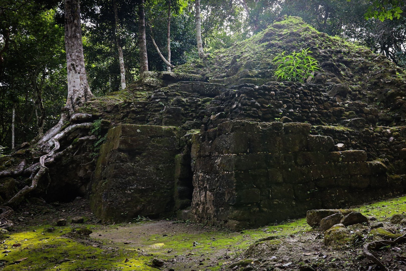
As it often does, the adrenaline (read: fear) I worked up inside the temple melts into elation at HOW COOL that just was. I beam over at Jeremy, then look back at the vegetation-covered, grey stone pyramid we just emerged from, one of the structures at the ancient La Muerta archeological site.
With that, Alfonso tells us, "Vamos" – let's go – and we continue on our 6-day, ~90 km journey through one of the wildest places I have ever been: the Maya Biosphere Reserve.
Established in 1990, the Maya Biosphere Reserve is a remote protected area in the northern region of Guatemala. Bordering Mexico, the reserve's dense rainforest enshrouds some of the most important Maya ruins in the world, including what was once one of the largest cities in the Maya civilization. Beyond its rich cultural heritage, the region is also the largest protected tropical forest in North America and a haven for wildlife – including jaguars, howler monkeys, pumas, tapirs, ocelots, and an impossible number of birds and insects.


Jeremy and I have come to this remote site in Central America not just to get up close and personal with giant cockroaches (romantic travel experiences <3), but to learn about the unique systems of land management and community conservation that are taking place in the Maya Biosphere Reserve – and more specifically, in the community of Carmelita, a small, traditional village in the Petén region of Guatemala that has been in this forest for over a century, and whose land concession we are currently trekking through.
First things first: for those of us who haven’t brushed up on land rights jargon in a while, what is a land concession?
A land concession is a grant by a government that gives land rights to another actor for a specific use. Land concessions are common on public lands – for example, when mining companies are given a concession to mine a specific area within a national park. In this case, a land concession was “given” by the Guatemalan government to the community of Carmelita, as part of its organization of the Maya Biosphere Reserve. The government divided the reserve into three zones:
Core zone: about 36% of the reserve, this zone consists of four national parks and three wildlife reserves, with the primary purpose of scientific research and low impact tourism.
Buffer zone: about 24% of the reserve, the buffer zone is a 15-km band along the southern border of the reserve.
Multi-use zones: the remaining 40% of the reserve, this portion is where things get interesting. The multi-use zones are a network of land concessions that were given to 12 community organizations and two private timber companies in the late 1990s and early 2000s – designed to give opportunities for sustainable, low-impact land use.
The process to secure a land concession in the multi-use zone was not simple (think: annual work plans, environmental impact analyses, financial management plans, NGO partnerships). And while the vetting process was designed with the goal of long-term environmental and community benefit – an arguably well-intentioned and worthy cause – Carmelita and other communities in the reserve had to go through years of bureaucracy to re-access land they had lived and worked in for decades. Their land was taken from them, just to be given back with more restrictions and more paperwork.
In late 1997, the Guatemalan state granted the Carmelita community a forest concession of 53,597 hectares. And in 1998, the Carmelita Cooperativa emerged as the local organization in charge of the conservation and management of their community concession. From then until now, the Cooperativa has managed aspects such as forest harvesting, carpentry, forest fire control, and tourism – which all generate employment for most of the families living in the community. Rather than strict preservation, the community uses sustainable management practices in their forests to achieve social, economic, and environmental benefits.


Our guide Alfonso is one of the many community members who now works for the Carmelita Cooperativa. A stoic, intelligent man in his early 30s, he grew up in the community, leaving just a couple times a year when medical or administrative reasons bring him to Guatemala City. As he has for years, he makes a living through guiding trips into the jungle like ours or tending to his farm.
As we walk through the jungle, Alfonso discusses the history of chicleros in northern Petén – the people who harvested chicle, or gum, for decades before the creation of any national park or reserve. When word got out that the abundant mounds scattered among the jungle contained extremely valuable Maya artifacts, many chicleros sought to improve their lives, padding their meager income by searching for ancient ceramics to sell. Local chicleros had ventured deeper into the jungle than anyone did for centuries seeking gum trees, so they could survive for days on end without getting lost, discovering and looting even the most remote Maya sites. When official archeological excavation began in the late 1990s, these same chicleros were often hired as part of expedition crews because of their existing knowledge of the forest and the Maya.

Today, the community of Carmelita is made up of the children and grandchildren of these chicleros, who now work to protect their region’s ancient heritage and manage their natural resources, all while diversifying their income through ecotourism. While Carmelita faces challenges, such as illegal logging, mafia presence at the northern border, and ensuring the entire community sees benefits of ecotourism, the cooperative still serves as a successful model for community management.
Picking our way through the jungle, we follow Alfonso, who follows the same path of the chicleros, who themselves followed the ancient roads of the Maya before them. As has been our routine the past couple days, our walk is not quite walking. More a combo of regularly sinking calf deep in the mud, macheting through the dense foliage, and traversing flooded areas on fallen branches doubling as makeshift bridges — all while balancing the ever-shifting equation of optimal skin exposure as a function of both temperature and mosquito aggression.


At long last, we arrive at our campsite for the day. Which also happens to be one of the most important and oldest Maya complexes in the world: El Mirador. That will have to wait until tomorrow though, because our first order of business after hiking since 5:40am is eating our weight in chips and Chiky cookies. Dinner is, in fact, only 2 hours away, but we all know full well that our appetites will rebound by then.
Stomachs full and legs sufficiently worked, we make one final push for the day: climbing the nearby El Tigre pyramid to watch sunset over the jungle.
As the sun sets above the canopy, cries of howler monkeys boom across the landscape. Alfonso regals us with tales of locals who tested the Maya spiritual presence by camping out alone on top of pyramids or in the ceremonial courtyards below – only to meet night terrors of being strangled by giant serpents or pulled out of their tents by unwelcoming spirits. Superstition or fact, the anecdotes project our imaginations millennia into the past, attempting to conceptualize the profound changes this landscape, culture, and people have seen in the last 3000 years since the Maya built their ancient cities here.


Darkness falls and we skip down the pyramid steps back to camp, not wanting to test the jungle after hours. Jeremy and I bid Alfonso and Javier “Buenas noches,” and crawl into our tent. Alarm set for 5:40 am once again, I anticipate what four more days in this one-of-a-kind place might hold (while checking my sleeping bag for spiders). We have only skimmed the surface of the innumerable historical and ecological treasures the Maya Biosphere Reserve and Carmelita concession contain, and two things are already clear: this area is vital to protect, and the Carmelita Cooperativa serves as an inspirational example of how community-based conservation can be a part of doing so.